Maps of the North of Chile
Visited by millions of national and international tourists every year: the north of Chile, with the desert of Atacama as its icon, excites with its incredible landscapes and the great possibilities for outdoor activities. Different parks and hiking trails convert into the perfect scene to practice trekking and excursions.
Below you find a small selection of the best publications of maps of the central zone of Chile:
Map Putre-Lauca
Travel & trekking map of the High Andes area in the extreme North of Chile, comprising the Putre area and Lauca National Park including Guallatiri volcano. With hiking routes, thermal springs, mountain huts and campsites, a register of tourism service providers, landscape pictures and drawings of the local fauna. Detail map 1:30,000 of the Putre area and local map of Putre. Buy now
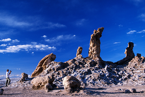
Map San Pedro de Atacama
Completely updated travel and trekking map of the Atacama region around San Pedro, between Calama and Paso Sico, in Northern Chile; reaches about 25 miles into Bolivian territory. With trekking routes, altitude levels each 100 m, GPS compatible. Hiking & Biking Map 1:50,000 of San Pedro's immediate surroundings. Landscape pictures and drawings of the Andean fauna. City Map of San Pedro. Developed by the Institute for Cartography at the Dresden Technical University. Buy now
Map Nevado Ojos del Salado
This mountaineering map shows the area around the Nevado Ojos del Salado, which is the highest volcano in the world at 6893 meters. Includes other mountains over five to six thousand metres, as Wheelwright, Pircas de Indios, Peñas Blancas, Ermitaño, Laguna Verde, Mulas Muertas, El Muerto, El Fraile, Cazadero. A detailed map shows the area around the peak of Ojos del Salado (scale: 1:35,000). The map includes roads, access slopes, ascending and climbing routes, lodges etc. Published by the German Alpine Association DAV AND developed by the Institute for Cartography at the Dresden Technical University. Buy now
The complete selection of travel guides and maps of the north, center and south of Chile you can find on maps.trekkingchile.com
