Maps of the central region in Chile
Leafy forests, endemic trees and lots of hiking trails of different grades of difficulty can be found in the central region of Chile, where emerge for example the national park La Campana in the region of Valparaíso and the national park Altos de Lircay more in the south, in the region of Maule.
Below you find a small selection of the best publications of maps of the central zone of Chile:
Map Cajón del Maipo
Professional Map of the upper Maipo valley southeast of Santiago, developed by the Institute for Cartography at the Dresden Technical University in cooperation with the German Andes Club. Overview map 1:100,000 showing the whole Cajón del Maipo with its sidevalleys El Yeso and El Volcán. Detail map 1:50,000 showing the High Andes section with Nature Preserve El Morado, Cerro Marmolejo (6108 m), San José volcano (5856 m) and lots more of trekking and climbing routes. GPS compatible, with level curves every 50 m, with mountain huts, thermal baths, lodgings, campsites, touristic services. Landscape pictures and drawings of the local fauna. Buy now
Map National Park La Campana
The first hiking map of National Park La Campana, in the Coastal Cordillera between Santiago and Viña del Mar. Includes Cerro La Campana (1828 m) and Cerro El Roble (2223 m). GPS compatible, with level curves every 50 m, trekking routes, access roads, campsites, etc.; Landscape pictures and a panoramic drawing of the local fauna and flora. Map developed by the Institute for Cartography at the Dresden Technical University. Buy now
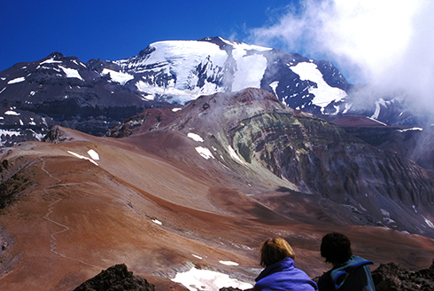
Map Condor Circuit
Completely revised map of the naturally beautiful and pristine territory between the natural preserves of Altos de Lircay and Siete Tazas, including Descabezado Grande volcano and the Condor Circuit hiking route. With level curves each 50 m, hiking routes, thermal baths, campsites and lodgings, landscape pictures and drawings of the local fauna. GPS compatible. QR codes take you directly to the tour descriptions in the Trekkingchile app. Detail maps 1:25,000 of the Radal Siete Tazas and Altos de Lircay nature preserves. Buy now
Map Altos de Teno
The first map of the Andes east of San Fernando and Curicó. Overview map 1:150,000 of the area between the volcanoes Tinguiririca (4280 m) and Planchón - Peteroa - Azufre (4113 m), including Volcán Planchón (3985 m), Cerro Alto del Padre (3349 m) and the private nature preserve Alto Huemul. Two detail maps 1:50,000: Reserva Alto Huemul and Planchón - Peteroa. GPS compatible, with hiking routes, level curves every 50 m, mountain huts, lodgings and campsites. Landscape pictures and drawings of the local fauna. Map developed by the Institute for Cartography at the Dresden Technical University. Buy now
The complete selection of travel guides and maps of the north, center and south of Chile you can find on maps.trekkingchile.com
Professional Map of the upper Maipo valley southeast of Santiago, developed by the Institute for Cartography at the Dresden Technical University in cooperation with the German Andes Club.
Overview map 1:100,000 showing the whole Cajón del Maipo with its sidevalleys El Yeso and El Volcán.
Detail map 1:50,000 showing the High Andes section with Nature Preserve El Morado, Cerro Marmolejo (6108 m), San José volcano (5856 m) and lots more of trekking and climbing routes.
GPS compatible, with level curves every 50 m, with mountain huts, thermal baths, lodgings, campsites, touristic services. Landscape pictures and drawings of the local fauna.
- See more at: http://maps.trekkingchile.com/chile-central/cajon-del-maipo#sthash.yOfp9nPd.dpuf